
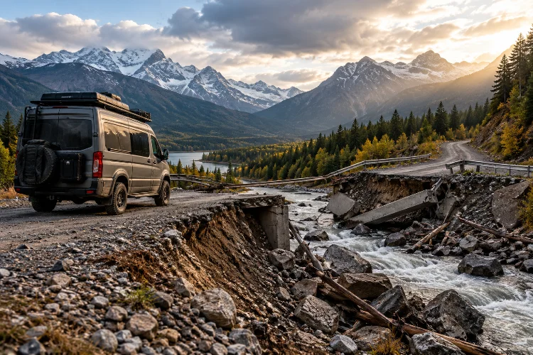
Imagine driving your adventure van through a remote mountain valley, surrounded by incredible scenery and endless stretches of wilderness. You’ve spent weeks planning the perfect overland route, and everything seems to be going smoothly.
Then, without warning, you reach a washed-out bridge. The road ahead is completely impassable, there’s no mobile signal, and the nearest town is several hours away.
What happens next depends largely on how well you’ve prepared.
Developing contingency routes for remote overland van adventures is about making sure unexpected obstacles don’t automatically become dangerous situations.
Whether you’re dealing with severe weather, mechanical trouble, seasonal closures, or unreliable road information, having alternative travel options can make a huge difference.
A good backup route isn’t simply another line drawn on a map. It should account for road conditions, fuel availability, vehicle limitations, communication coverage, and emergency access.
The goal isn’t to eliminate every possible surprise. After all, unpredictability is part of what makes overlanding exciting.
Instead, it’s about building enough flexibility into your expedition to make safer decisions when your original plan stops working.
1. Why Contingency Route Planning Matters for Remote Overlanding
Remote overland travel offers a level of freedom that traditional road trips rarely provide.
You can explore isolated landscapes, discover quiet camping areas, and travel far beyond established tourist destinations. However, that freedom comes with a few additional responsibilities.
When you’re hundreds of kilometres from major services, even minor problems can become complicated.
Understand the Risks of Remote Route Dependence
Relying on a single travel route creates unnecessary vulnerability.
A flooded river crossing, unexpected landslide, closed mountain pass, or damaged track might prevent you from reaching your next destination.
In populated areas, finding another road is usually straightforward. Remote landscapes are different because alternative routes may involve substantial detours or terrain unsuitable for your vehicle.
The US National Park Service warns that backcountry roads can change significantly due to weather, while emergency assistance may be delayed for long periods.
These challenges highlight the importance of having alternative travel plans before leaving established road networks.
Think Beyond Mechanical Emergencies
Many travellers associate contingency planning with vehicle breakdowns, but route disruption can happen even when your van operates perfectly.
Wildfires may lead to temporary road closures. Heavy rainfall can damage gravel surfaces, while early snowfall might make mountain crossings inaccessible.
Unexpected medical concerns, fuel shortages, or changes in travel regulations can also force an itinerary adjustment.
A reliable expedition plan considers these possibilities without becoming unnecessarily complicated.
Instead of predicting every possible event, focus on identifying situations that could prevent you from continuing safely.
2. Build Primary, Secondary, and Emergency Exit Routes
One of the most practical approaches to overland expedition planning is creating several route options for each remote section.
This doesn’t mean preparing three completely different holidays.
It means designing an itinerary that includes realistic alternatives whenever your original route becomes unavailable.
Create a Three-Level Route Strategy
Start with your primary route, sometimes called Route A.
This is your preferred journey, including scenic roads, planned overnight stops, and specific destinations.
Next, develop Route B as a practical alternative.
Ideally, it should avoid the main hazards affecting Route A while remaining compatible with your vehicle’s capabilities.
Finally, identify Route C as an emergency exit.
Rather than prioritising scenery, this option should lead towards a reliable road network, populated area, or suitable location where assistance may be available.
For example, your primary route might cross a remote mountain plateau, while the secondary option follows a lower-altitude valley.
The emergency exit could involve returning along a previously confirmed accessible road towards the nearest service town.
Identify Decision Points Before Entering Remote Areas
A backup route becomes more useful when you know exactly where to switch plans.
Look for significant junctions, fuel stations, ranger facilities, or settlements where you can reassess conditions safely.
These become your route decision points.
At each location, review the latest available information about the road ahead, remaining daylight, and vehicle condition.
If your next alternative junction lies 80 kilometres away, make sure you have sufficient resources to reach it without relying on uncertain shortcuts.
Clearly marking these locations on offline maps makes decisions considerably easier when conditions become stressful.
3. Verify Alternative Routes Using Reliable Navigation Sources
Digital mapping tools have transformed overlanding, but they aren’t always reliable in remote environments.
A road displayed on a navigation app might be abandoned, seasonally restricted, privately controlled, or completely unsuitable for a campervan.
That’s why confirming the accessibility of alternative routes is just as important as identifying them.
Combine Digital Maps With Official Road Information
Satellite imagery and detailed topographical maps can help reveal terrain, elevation changes, road networks, and natural obstacles.
However, they don’t necessarily confirm whether a route is legally open or physically passable.
In the United States, the Forest Service publishes Motor Vehicle Use Maps showing designated roads, permitted vehicle types, and seasonal restrictions.
These maps help travellers distinguish legal vehicle routes from tracks that may not be available for public motorised access.
The Bureau of Land Management also provides public land access information, although legal access doesn’t guarantee that a road is suitable for your specific vehicle.
Outside the United States, use equivalent national road authorities, land-management agencies, park services, and local regulations.
Evaluate Road Conditions Against Your Vehicle
A four-wheel-drive campervan doesn’t automatically have the same capabilities as a purpose-built expedition vehicle.
Ground clearance, wheelbase, tyre selection, weight, suspension geometry, and approach angles all affect what terrain can be negotiated safely.
A narrow forest track might appear manageable on a map but become impractical for a long-wheelbase van.
Likewise, steep rocky sections can create problems for vehicles carrying heavy water tanks or low-mounted electrical equipment.
Evaluate each alternative route using your actual vehicle dimensions and capabilities, not simply its four-wheel-drive badge.
If reliable information is unavailable, treat the route as unverified rather than assuming it will be suitable.
4. Prepare Backup Routes for Weather and Seasonal Disruptions
Weather is one of the biggest variables in remote overland travel.
A track that feels perfectly manageable in dry conditions might become extremely dangerous after heavy rainfall.
Seasonal changes can also affect access, particularly in mountain ranges, deserts, and northern wilderness regions.
Identify Weather-Related Route Hazards
Different landscapes create different challenges.
Desert tracks may experience flash flooding, mountain passes can develop ice or snowfall, and forest roads may become impassable because of mud or fallen trees.
The US National Weather Service warns that floodwater can conceal damaged road surfaces and strongly advises drivers never to enter flooded roads.
Importantly, dangerous flooding can occur downstream from rainfall that isn’t happening at your immediate location.
For overland van travellers, the safest alternative is usually a verified route that avoids the affected area entirely.
Never assume that a higher-clearance vehicle makes an uncertain water crossing safe.
Establish Clear Turnaround Conditions
It’s useful to decide in advance which situations would cause you to abandon the planned route.
For example, your plan might require turning back if a crossing is flooded, official access is closed, or road deterioration exceeds the van’s capabilities.
You should also consider visibility, weather warnings, remaining daylight, and the condition of your tyres.
These decisions become harder when you’ve already driven for several hours towards a particular destination.
Establishing clear limits beforehand reduces the temptation to continue simply becuase you’ve invested time in getting there.
Adjust Your Itinerary for Seasonal Accessibility
High-altitude routes may remain closed long after nearby valleys become accessible.
Meanwhile, desert regions can experience extreme summer temperatures that make remote breakdowns particularly hazardous.
Research historical opening periods and expected weather conditions, but verify actual road status shortly before travelling.
A flexible itinerary allows you to change the order of destinations when conditions become unfavourable.
Sometimes reversing your travel direction or delaying a remote section is more practical than attempting a long detour.
5. Calculate Fuel, Water, and Supply Reserves for Alternative Routes
A backup route isn’t particularly helpful if your vehicle lacks the resources to complete it.
Remote detours can increase travel distances considerably, especially when the nearest alternative road lies far from your original itinerary.
This makes resource planning a central part of contingency route development.
Calculate Fuel Requirements for Your Longest Practical Detour
Suppose your primary remote route covers 250 kilometres.
Your adventure van normally consumes approximately 12 litres of diesel per 100 kilometres under comparable driving conditions.
The estimated fuel requirement becomes:
Fuel Required = Distance × Fuel Consumption ÷ 100
250 × 12 ÷ 100 = 30 litres
Now imagine your verified alternative route covers 400 kilometres.
Using the same consumption assumption, that journey would require approximately 48 litres.
That’s an additional 18 litres before accounting for terrain, idling, or unexpected delays.
In reality, steep gradients, soft surfaces, and heavy vehicle loading may increase fuel consumption.
Plan around a conservative estimate based on your vehicle’s actual performance, with a suitable reserve for unexpected changes.
Include Water and Food in Your Route Calculations
Water requirements depend on the environment, activity level, and number of passengers.
Hot weather and physically demanding activities can substantially increase daily consumption.
The National Park Service recommends carrying additional water and food when travelling through remote backcountry environments.
Rather than planning supplies exclusively around your expected arrival date, consider how long you could remain safely at a location if the vehicle became immobilised.
If your planned remote section takes two days, carrying enough supplies for additional delays may provide an important safety margin.
Keep emergency drinking water seperate from normal household use whenever practical.
Build Time Reserves Into the Expedition
Long-distance overlanding isn’t just about distance.
Unpaved roads can require significantly more driving time than the same distance on a highway.
A 100-kilometre gravel section averaging 25 km/h would take approximately four hours of actual driving, excluding stops.
Route changes can therefore create unexpected overnight requirements.
Avoid scheduling critical appointments, border crossings, or non-refundable bookings immediately after challenging remote sections.
A little flexibility makes it easier to prioritise safe decisions instead of rushing towards an unrealistic deadline.
6. Create Reliable Offline Navigation and Emergency Communication Plans
When mobile reception disappears, navigation becomes considerably more demanding.
Remote regions may offer little or no internet connectivity, and cloud-based maps can become inaccessible exactly when you need them.
A dependable expedition strategy should work without a mobile network.
Prepare Multiple Navigation Options
Download detailed maps of your primary and alternative routes before departure.
Include nearby settlements, fuel stations, known water sources, legal overnight locations, and potential emergency exits.
Offline navigation applications can be extremely useful, but don’t rely exclusively on a single device.
The National Park Service recommends carrying backup paper maps because smartphones can run out of power, become damaged, or provide unreliable directions.
A separate GPS device may offer additional redundancy, particularly when travelling through complicated terrain.
Check that downloaded maps actually work in aeroplane mode before leaving reliable coverage.
Share Your Expedition Plan With Someone You Trust
An external contact can provide valuable assistance if you fail to return or check in as expected.
Share your intended route, alternative options, vehicle description, and expected travel schedule.
Include agreed check-in times and clear instructions about when your contact should alert the appropriate authorities.
The National Park Service provides a trip-planning guide that explains how sharing these details can assist emergency responders.
When you change routes, update your contact whenever communication is available.
This simple habit can prevent confusion if your plans change unexpectedly.
Consider Satellite Communication for Isolated Areas
Satellite communicators can provide messaging capabilities beyond normal mobile phone coverage.
Some devices also support emergency SOS functions that connect users with response coordination services.
However, satellite communication isn’t guaranteed in every situation.
Garmin explains that its inReach devices require an active subscription for satellite services and need a sufficiently clear view of the sky.
Deep canyons, obstructions, and other environmental conditions can interfere with reception.
Test your equipement before departure, check local regulations, and understand the limitations of your particular device.
Emergency communication should support a broader safety strategy rather than replace careful route planning.
7. Make Better Decisions When Your Original Route Becomes Unavailable
Even the most detailed contingency plan needs to remain flexible.
Road conditions change, information becomes outdated, and unexpected situations rarely unfold exactly as imagined.
The important skill is knowing how to respond without making the problem worse.
Stop and Reassess Before Choosing a Detour
When you encounter an unexpected obstacle, find a safe place to stop.
Review your location, identify the nature of the problem, and check your available resources.
Consider whether the obstacle affects only your primary route or might also compromise nearby alternatives.
For example, heavy rainfall causing one river crossing to become impassable may affect several other crossings in the same drainage area.
Simply selecting another nearby track could expose you to the same hazard.
Instead, choose a verified alternative that avoids the broader risk.
Use a Simple Go-or-No-Go Decision Process
Before continuing, ask whether the proposed route is legally accessible, appropriate for your vehicle, and supported by reliable information.
Then assess whether you have enough fuel, water, daylight, and communications capability to complete it safely.
If any essential condition cannot be met, consider returning to your last confirmed safe location.
Imagine reaching a mountain junction at 3 PM after discovering that your planned pass is closed.
Your secondary route involves another four hours of difficult driving, while the emergency exit follows a known paved road to a nearby town.
If darkness, weather, or fatigue creates additional uncertainty, the safer exit may be the better choice.
Changing plans doesn’t mean the expedition has failed. It means your contingency strategy is working.
Learn From Each Route Adjustment
Every expedition provides useful information about your vehicle and planning assumptions.
Record unexpected road conditions, inaccurate maps, fuel consumption, and the effectiveness of your alternative routes.
Over time, you’ll develop a better understanding of how far your van can travel comfortably in different environments.
Reviewing these observations also helps identify unnecessary risks in future itineraries.
Update saved maps and travel notes occassionally so outdated information doesn’t become part of your next adventure.
Responsible overlanding also means respecting official closures and staying on legally designated routes, even when an improvised shortcut appears tempting.
The most valuable contingency plan is one that protects passengers, respects local environments, and keeps future adventures possible.
Developing contingency routes for remote overland van adventures is one of the most practical ways to improve safety, confidence, and flexibility.
By creating primary, secondary, and emergency exit routes, you can respond more effectively to unexpected closures, deteriorating weather, and changing travel conditions.
Reliable navigation, realistic fuel calculations, adequate supplies, and clear communication plans all contribute to a more resilient expedition strategy.
Remember that the best backup route isn’t necessarily the shortest. It’s the one you can legally and safely complete with the resources available.
Before your next remote journey, review your itinerary, identify critical decision points, and prepare realistic alternatives.
A little additional planning can turn a potentially stressful detour into another memorable part of your overland adventure.
